
Ficheiro:16-07-06-Rathaus Graz Turmblick-RR2 0275.jpg
Ficheiro orixinal (4.288 × 2.848 píxeles; tamaño do ficheiro: 9,76 MB; tipo MIME: image/jpeg)
Resumo
| Descrición |
Deutsch: Schloßberg Graz, Blick von der Turmspitze des Rathauses
Čeština: Štýrský Hradec, pohled z věže radnice
Català: Castell del Pujol Graz, vista des de la torre de l'ajuntament
Español: Castillo de la Colina Graz, vista desde la torre del ayuntamiento
Русский: Шлоссберг Грац, Вид с башни ратуши
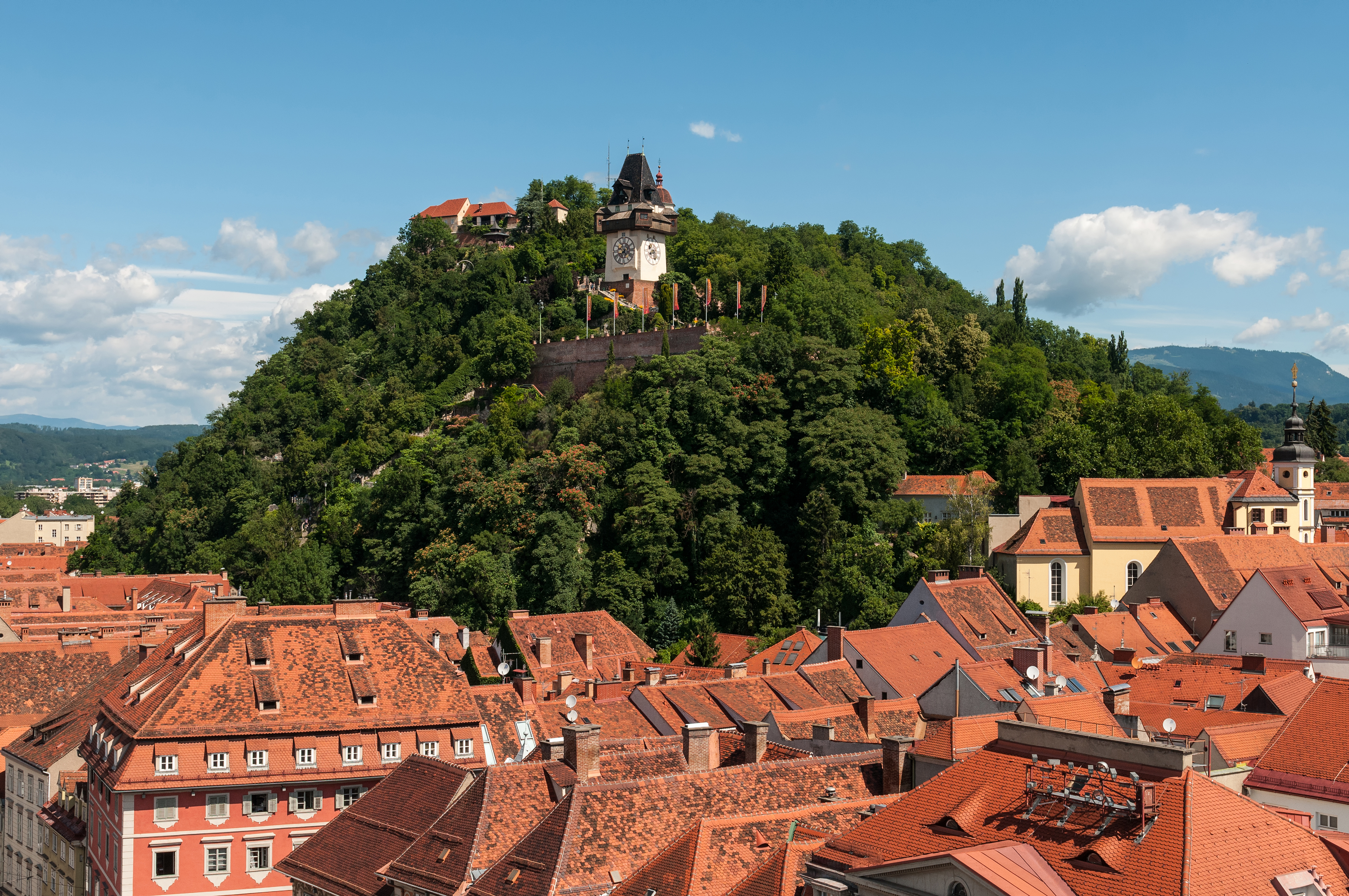
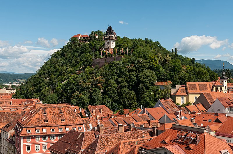
English: Castle mountain Graz, view from the spire of the town hall
|
|||||||||||||||||||||||
| Data | ||||||||||||||||||||||||
| Orixe | Obra propia | |||||||||||||||||||||||
| Autoría |
|
|||||||||||||||||||||||
| Licenza (Reuso deste ficheiro) |
|
|||||||||||||||||||||||


| Localización da cámara | | Esta e outras imaxes na súa localización en: OpenStreetMap |
|---|
| Localización do obxectivo | | Esta e outras imaxes na súa localización en: OpenStreetMap |
|---|
Valoración
|
Esta imaxe foi elixida como imaxe do día do 6 de xullo de 2023. O seu pé de foto foi: English: Castle mountain Graz, view from the spire of the town hall. Outras linguas:
Čeština: Mohutná skála Schloßberg nad rakouským Štýrským Hradcem (Gratzem), z jehož radniční věže byl nafotografován tento snímek. Deutsch: Der Grazer Schloßberg. English: Castle mountain Graz, view from the spire of the town hall. Español: Schloßberg, vista desde la torre del ayuntamiento. Français : Le Schloßberg, colline de Graz (Autriche) abritant un jardin public et une forteresse. Vue ici depuis la tour de l'hôtel de ville. Italiano: Vista del monte castello di Graz dalla guglia del municipio, nella città di Graz in Austria. Nederlands: Blik op de Uhrturm op de Schlossberg in Graz, de hoofdstad van de Oostenrijkse deelstaat Stiermarken Português: Montanha do castelo em Graz, Áustria, vista da torre da prefeitura. |
Esta imaxe foi avaliada segundo os criterios de imaxe de calidade e considérase unha imaxe de calidade.
|
Wikipedia-Landtagsprojekt/Steiermark 20165. of July 2016 in Graz More than 10 persons participated in this project voluntarily and without expense allowance.
|
|
 |
Usage informationIf you need more information how to use this file, please send an |
|
The making of this work was supported by Wikimedia Austria. For other files made with the support of Wikimedia Austria, please see the category Supported by Wikimedia Österreich. |
A confecção desta obra foi da Skillshare.
Para ver outros ficheiros criados com o apoio da Wikimédia Alemanha, veja a categoria Supported by Skillshare. |
- Vostede é libre de:
- compartir – copiar, distribuír e difundir a obra
- facer obras derivadas – adaptar a obra
- Baixo as seguintes condicións:
- recoñecemento – Debe indicar a debida atribución de autoría, fornecer unha ligazón á licenza e indicar se se realizaron cambios. Pode facer isto de calquera forma razoable, mais non nunha forma que indique que quen posúe a licenza apoia ou subscribe o seu uso da obra.
- compartir igual – Se altera, transforma ou amplía este contido, debe publicar as súas contribucións baixo a mesma licenza ou outra compatible á orixinal.

Licenza

|
Autorízase a copia, distribución e/ou modificación deste documento baixo os termos da licenza de documentación libre GNU, versión 1.2 que publique a Free Software Foundation; sen seccións invariables, textos de portada, nin textos de contraportada. Inclúese unha copia da devandita licenza na sección titulada GNU Free Documentation License. | 1.2 só |
Historial do ficheiro
Prema nunha data/hora para ver o ficheiro tal e como estaba nese momento.
| Data/Hora | Miniatura | Dimensións | Usuario | Comentario | |
|---|---|---|---|---|---|
| actual | 8 de xullo de 2016 ás 22:45 | | 4.288 × 2.848 (9,76 MB) | Ralf Roletschek | sky denoised |
| 8 de xullo de 2016 ás 20:26 |  | 4.288 × 2.848 (10,28 MB) | Ralf Roletschek |
Ligazóns de imaxe
Ningunha páxina liga con esta imaxe.
Uso global do ficheiro
Os seguintes wikis empregan esta imaxe:
- Uso en am.wikipedia.org
- Uso en an.wikipedia.org
- Uso en ar.wikipedia.org
- Uso en arz.wikipedia.org
- Uso en ast.wikipedia.org
- Uso en av.wikipedia.org
- Uso en az.wikipedia.org
- Uso en ban.wikipedia.org
- Uso en ba.wikipedia.org
- Uso en be-tarask.wikipedia.org
- Uso en bg.wikipedia.org
- Uso en bn.wikipedia.org
- Uso en ca.wikipedia.org
- Uso en ceb.wikipedia.org
- Uso en ce.wikipedia.org
- Uso en cs.wikipedia.org
- Uso en cv.wikipedia.org
- Uso en cy.wikipedia.org
- Uso en de.wikipedia.org
- Österreich
- Belagerung von Graz
- Wikipedia:Landtagsprojekt/Steiermark/Locations
- Wikipedia Diskussion:Hauptseite/Artikel des Tages/Archiv/Vorschläge/2018/Q1
- Wikipedia:Hauptseite/Archiv/13. März 2018
- Portal:Österreich/RegiowikiAT Redundanzen
- Benutzerin:Alfonsina2019
- Liste der denkmalgeschützten Objekte in Graz/Innere Stadt/O–Z
- Wikipedia:WikiProjekt Österreich/checks/Denkmalschutz/WP - WD diffs 02
- Uso en de.wikiversity.org
- Uso en de.wikivoyage.org
- Uso en de.wiktionary.org
- Uso en el.wikipedia.org
- Uso en en.wikipedia.org
- Uso en en.wikivoyage.org
- Uso en eo.wikipedia.org
- Uso en eo.wikivoyage.org
- Uso en eu.wikipedia.org
- Uso en fa.wikipedia.org
- Uso en fi.wikipedia.org
Ollar o uso global deste ficheiro.